First of all, probably the most detailed map of Turkana that you'll find anywhere:
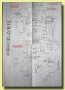
Turkana Map
Turkana is a remote region in North-western Kenya. It is easy to get up there, even with public transportation. But the entire region is barely even mentioned in Lonely Planet so correspondingly you'll be unlikely to see any other tourists.
Disclaimer: Turkana is a bit dangerous (so is Nairobi, or my hometown of Oakland), but with a bit of caution - or even without any caution at all - you'll probably be fine. You'll have to make your own decisions about the safety.
Here were my thoughts after talking to members of the Red Cross who worked in the area:
"The path I'm taking is not 100% safe, but it's not so dangerous either. The nomadic Merile people of Ethiopia occasionally get hungry come down to Kenya, kill some herders and steal their cattle and sheep. Then the Turkana will get hungry go up to Ethiopia kill some herders and steal the cattle and sheep back. The raids always happen late at night and are always for sheep and cattle. To these nomads cows are holy - they live for and from the cows. Some of the nomads in the area subsist only off the milk and blood of the cows. The nomads have no interest in me, my money, or my camera. They are not part of the modern world and aren't part of the cash economy. I should be fine. There are however a few bandits..."
Lodwar

Lodwar
I really liked Lodwar. It's a small dusty town, but it has character. You could easily spend a couple of days here.
Hotel Recommendation:
Miami Hotel (price?? I don't remember, but cheap). The owner Peter is a very nice guy who works at the Catholic Diocese and should be able to help you with travel arrangements.
Restaurant Recommendation:
Salaam Restaurant -- they make a pretty good plate of spaghetti.
Heading North or East:
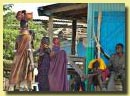
Turkana Women
Lodwar is the major town in the Turkana region so it is also the transport hub.
Lokichoggio -- Getting up to Lokichoggio is easy -- matatus and buses run several times a day. The UN built a new road here, so it's only a fast smooth 3-hour ride out to Lokichoggio.
Kalikol -- There seems to be at least one matatu a day going to Kalikol.
Eliye Springs -- I didn't go, and don't have any solid info for you. Maybe someone else can help me fill this in. Lonely Planet's info seems way out of date. I think with a bit of patience, you'll have no problem finding a matatu heading that way.
Laurengak, Kibish and anywhere else -- wait around long enough and you can find a ride almost anywhere with a matatu, a UN food truck, or the police. It took a long time to get info if the trip was safe, but after that I had no problem finding a UN food truck heading up the Laurengak.
Heading South:
Buses run daily down to Eldoret or Nairobi.
Kalikol

Kalikol
A true shithole. I'm a very positive person, but this is a horrible place with no character and nothing to see or do.
There is one hotel with tiny dirty rooms with mud walls and a thatched roof. I can't really recommend it, but it is a place to stay.

My birthday suite
Eliye Springs
Sorry, I don't have any info.
Lokichoggio
Lokichoggio is more a UN camp than a town. What there is of the towns seems to have mostly sprung up around the camp. An interesting bit of trivia is that Lokichoggio in this extremely remote corner of Kenya has the 2nd (3rd?) busiest airport in Kenya with aid flights constantly landing and taking off again.
I was only in Lokichoggio for an hour getting my passport stamped out of Kenya. I heard rumors of a hotel for $20/night. If you look around, there might also be cheap local hotels.
Laurengak
A large village near the shore of Lake Turkana with a Catholic Mission. I showed up late at night and spent the first night at the house of an English speaking nurse that I met on the bus.
After that the Mission took me in. They have a couple of extra rooms and let me stay for free. The next morning they gave me a free ride up to the border with a road crew that was heading that way.
Father Francis at the Mission is an amazing guy -- a young energetic Malaysian that speaks at least 6 languages and travels freely between the warring tribes. He should be able to help you out with a place to stay, travel information, and possibly even a ride.
This is the last place that you'll be able to buy food heading north. There is a tea shop that mostly served tea and bread, but it doubled as a restaurant. When I was there they had chicken and pasta on the "menu". Be sure to order ahead of time; they have to catch the chicken before they serve it to you.
Heading South -- you should be able to catch a ride with an aid truck or something else.
Heading North -- there isn't much North of here, but you should be able to catch a ride with someone from the Mission or with the police. I had no trouble at all finding a ride.
Todenyang / Kenyan Police Checkpoint

On to Ethiopia
It's labeled on the map, but I don't think that there is actually a town or village here. There is an army base and the police border checkpoint.
You should be able to sleep at the fenced in police station if necessary.
Heading South -- ummm.... I was going the other direction, so I don't have any solid info for you. I suspect that the police and/or army head down towards Laurengak or further all of the time and that you should be able to catch a ride with them, but don't have any details. You could possibly be stuck here for a couple of days -- be prepared for that.
Heading North -- from here it's on foot. There is a well-marked trail from the Kenyan police checkpoint to the Ethiopian police checkpoint. This is the "no mans" land between Kenyan and Ethiopia -- and as it is named it should be safe and empty -- at least during the day. Just be warned though, there is no shade at all along the way.
Ethiopian Police Checkpoint
Now you're in the middle of nowhere. The Kenyan police checkpoint was a bit structured with a fence and a couple of policemen sitting around playing cards. They couldn't care less about a foreigner with a backpack showing up. The Ethiopian checkpoint is a watchtower and a couple of houses on the top of a small hill. It was total mayhem with women and children running around -- everyone absolutely fascinated with me and my luggage.
Bring presents! Anything that you bring will very much appreciated.
You can sleep at the base of the watchtower. They walk 3k each way to get water from the river. All the food that they have seems to be plain injeera. You should bring your own food, but it would be nice if you had some to share.
Heading South - a well-marked 5k walk down to the Kenyan police checkpoint. This is the "no mans" land between Kenyan and Ethiopia -- and as it is named it should be safe and empty -- at least during the day. Just be warned though, there is no shade at all along the way.

Heading North - this is the most difficult and perhaps most dangerous part of the journey. It is about a 15k walk from the Ethiopian police checkpoint to the river crossing along a fairly well marked path. This is remote nomad country and many of the nomads are armed. Arrange a guide at the Ethiopian police checkpoint to take you at least as far as the river. I did not, but I cannot recommend the experience, it certainly could have turned ugly. You'll know you reached the right spot for the river crossing by the windmills. An American is involved in a wind-powered hydration project here. He wasn't around when I came by, but perhaps he'll give you a place to stay.
A s-shaped canoe made from a single tree trunk can take you across the river here. But you'll have to pay him a birr or two for the ride. If you don't have any he'll probably take Kenyan shillings. From the river crossing it's about another 10k into Omorate. Almost immediately after I started walking a truck showed up and picked me up (though I had to pay for the ride). I do not know if I was extremely lucky in catching this ride or if it was typical. You could possibly have to walk this additional 10k, so be prepared for it.
Galeb Village on Lake Omo
I didn't have the energy or the food to spend an extra day at the Ethiopian police checkpoint and take a trip down here, but it sure sounded interesting. It's right on the river, only 3k away from the police checkpoint and is completely un-touristed.
"Completely untouristed" -- Am I ruining that? If I didn't would it be bound to happen anyways?
Omorate

Like a Sore Thumb
I really liked Omorate. You know that you're far from civilization when people start begging you for your empty plastic water bottles. They're a hell of a lot easier to carry around than clay pots. If you're heading south, this is just a bit more remote than Turmi and such. But if you're heading north, this place can be very special. I really would recommend hanging out for a while and learning a bit about the Ethiopian culture and a bit of the language too.
Note -- Heading South this is the last place that you'll be able to buy food.
Hotel recommendation: There are only 3 hotels in town and they're all on the same street corner. I would not recommend the one to the right (if you're facing them) -- they overcharged me and weren't particularly friendly. I did not try the one on the left. But the one in the middle (I'm 90% sure that it's the National hotel) was fantastic. The owner and the people who worked there were super-welcoming and friendly.

People of Omorate
Cultural note from my journal:
"The hardest thing for me about Ethiopia is the complete lack of personal space and what we'd call 'respect' for personal property. Everything I own is constantly picked up, looked at, and fondled. Every time that I sit down in the restaurant, someone grabs my guidebook and flips through it. Someone else picks up the novel I'm reading. Yet a third person takes my pen and starts playing with it. I'm left with only my cup of tea. Everything is always returned, but it's nerve wracking. "
It might be stressful, but here in Omorate that people were just being friendly. Like I did, you might have to first learn to live with and then later learn to enjoy the cultural differences.
Heading East - big Bedford trucks carrying passengers and cargo leave here every day or two heading out to Turmi or beyond.
Heading South - this is the most difficult and perhaps most dangerous part of the journey. It is almost 30k from Omorate to the Ethiopian police checkpoint
Arrange for a guide to take you there. You'll be heading into remote nomad country and many of the nomads are armed. I did not arrange a guide, but I cannot recommend the experience; it could have turned ugly.
Also arrange for a car or motorbike to take you and your guide to the river crossing. You'll know the right spot by the windmills. An American is involved in a wind-powered hydration project here. He wasn't around when I came by, but perhaps he'll give you a place to stay.
You'll have to pay a birr or two to cross the river in a bizarre s-shaped canoe made from a single tree-trunk. From across the river, it's about a 15k walk to the Ethiopian police checkpoint along a fairly well marked path. This area can be dangerous so make sure that you do it with a guide and during the day. The Ethiopian police checkpoint is easily distinguishable with its watchtower on top of a small hill.
Visas
You cannot get visas at the border in Turkana/Omorate. You should get your visas ahead of time at either Nairobi or Addis Ababa.
There is now an immigration office in Omorate. You can get stamped into or out of Ethiopia at this immigration office.
There is NO immigration on the Kenyan side of the border or in Lodwar. You either have to travel up to Lokichoggio (as I did), or you can just do it way down in Eldoret or even Nairobi.
Money
You can exchange Kenyan shillings into Ethiopian birr or vice versa in Omorate. I suspect that you can also change money in Lodwar or Lokichoggio. You might also be able to exchange dollars, but I doubt you'll find anyone who takes travelers checks.
Traveling by Car or Motorcycle
If you're traveling by car you cannot cross the Omo River in Omorate. Though, it may be possible to do so much further North in the Mago National Park.
It is possible to cross the river in Omorate if you're on motorcycle. There is one boat big enough to carry the bikes across one at a time. However, it's a monopoly and the prices for transporting by bikes across the river will be not cheap.
Petrol - you should be able to get petrol in Omorate. There is an actual gas station in Omorate. In between, the army post near Todenyang or the mission in Loarengak should be able to help you out in an emergency.
Note: Still a rough draft. Let me know if there is anything that I left out. If you have any additional information let me know and I'll add it.
